ආයුබෝවන් අපගේ වෙබ් අඩව්යට පෑමිණි ඔබව සාදරයෙන් පිලිගනිමු
About Our Country
Our History
The chronicle records and archaeological discoveries of human beings and their events which happened in an area known as Sri Lanka is called the History of Sri Lanka. The number of archaeological evidences and chronicles written by Sri Lankans and non-Sri Lankans, exploring the history of more than 10,000 years.The archaeological discovery of the Balangoda Man providing the evidences of a 30,000 years past civilization. With the famous chronicles of Sri Lanka, the Mahawansa, the Dipavamsa, the Culavamsa and the Rajaveliya which has the recorded Sri Lankan history from the beginnings of the Sinhalese monarchy in the 6th century BC to the arrival of European Colonialists in the sixteenth century, up until the disestablishment of the monarchy in 1815. There are some historical records about the country also included in the famous Indian chronicles of sage Valmiki's Ramayana, Mahabharata and the ancient books of Gautama Buddha's teachings.
The period after sixteenth century, some coastal areas of the country was ruled by the Portuguese, Dutch and British. After the year 1815 the entire nation was ruled by the British Colonialists until the political independence granted in 1948 and becomes a sovereign state after 1972. The Sri Lankan people's armed uprisings happened against the British colonial rule in 1818 Uva Rebellion and in 1848 Matale Rebellion.
The new constitution was introduced in 1978 the Executive President as the head of state, was happened after the armed youth uprising in 1971 known as 1971 April Rebellion. The Sri Lankan Civil War started in 1983 and again another armed youth uprising happened in 1987-89 period and the 26 year civil war ended in year 2009.
The significant cultural changes happened after introducing the Buddhism in 3rd century BC by Arhath Mahinda (was the son of Indian emperor Ashoka the Great), after sixteenth century arrival of European Colonialists and after 1977 the new open economic policies also changed the cultural values in the country.
Geography and climate
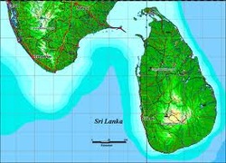
The island of Sri Lanka lies in the Indian Ocean, to the southwest of the Bay of Bengal. It is separated from the Indian subcontinent by the Gulf of Mannar and the Palk Strait. According to Hindu mythology, a land bridge to the Indian mainland, known as Rama's Bridge, was constructed during the time of Rama by the vanara architect Nala. Often referred to as Adam's Bridge, it now amounts to only a chain of limestone shoals remaining above sea level.[19]
According to colonial British reports, this is a natural causeway which was formerly complete, but was breached by a violent storm in 1480.[20] The island consists mostly of flat-to-rolling coastal plains, with mountains rising only in the south-central part. Amongst these is the highest point Pidurutalagala, reaching 2,524 metres (8,281 ft) above sea level.
The climate of Sri Lanka can be described as tropical and warm. Its position between 5 and 10 north latitude endows the country with a warm climate moderated by ocean winds and considerable moisture. The mean temperature ranges from about 16 °C (60.8 °F) in the Central Highlands, where frost may occur for several days in the winter, to a maximum of approximately 33 °C (91.4 °F) in other low-altitude areas. The average yearly temperature ranges from 28 °C (82.4 °F) to nearly 31 °C (87.8 °F). Day and night temperatures may vary by 4 °C (7.20 °F) to 7 °C (12.60 °F). During the coldest days of January, many people wear coats and sweaters in the highlands and elsewhere.
May, the hottest period, precedes the summer monsoon rains. The rainfall pattern is influenced by monsoon winds from the Indian Ocean and Bay of Bengal: as the winds encounter the mountain slopes of the Central Highlands, they unload heavy rains on the slopes and the southwestern areas of the island. Some of the windward slopes receive up to 2,500 millimetres (98.4 in) of rain each month, but the leeward slopes in the east and northeast receive little rain. Periodic squalls occur and sometimes tropical cyclones bring overcast skies and rains to the southwest, northeast, and eastern parts of the island.
Between December and March, monsoon winds come from the northeast, bringing moisture from the Bay of Bengal. Humidity is typically higher in the southwest and mountainous areas and depends on the seasonal patterns of rainfall, and places like Colombo experience daytime humidity above 70% all year round, rising to almost 90% during the monsoon season in June. Anuradhapura experiences a daytime low of 60% during the monsoon month of March, but a high of 79% during the November and December rains. In the Kandy's daytime humidity usually ranges between 70% and 79%.


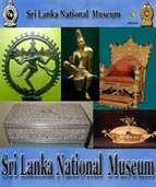
Sri Lanka National Museum


 Sri Lanka Rupee Converter